

This transcontinental route was conceived by J.W. Parmley of Ipswitch, SD, in 1912.
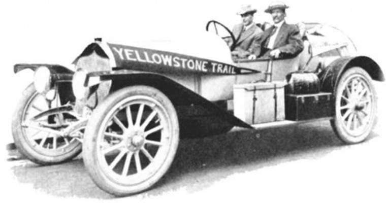
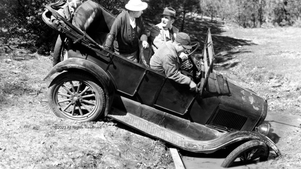
The automobile was just becoming popular but intercity roads were plagued with sand, potholes and mud.
Bicyclists of the previous decade, organized as the Wheelmen and counting thousands as members, had been pushing state and federal governments for years for roads.
Yet, in 1912, there were few good, all weather roads, no useful long distant roads and no government marked routes.
Railroads had been the dominant, almost sole, method of travel but were losing their allure because of monopolistic freight rate-
The privacy and autonomy of the automobile was not to be denied.
The Yellowstone Trail developed in parallel with the nationwide effort to improve roads.
The burden of financing roads gradually moved from the local landowner and township up the levels of government until the federal government, the states, the counties and the townships shared the cost.
The burgeoning number of autos resulted in a demand for roads to drive them on, first for pleasure and then for crucial societal purposes: for doctors to get to patients, for farm products to get to the railroads, and for military purposes.
The words above are partially from the Yellowstone Trail Association’s website, a non-profit organization dedicated to researching, promoting, and driving the route.
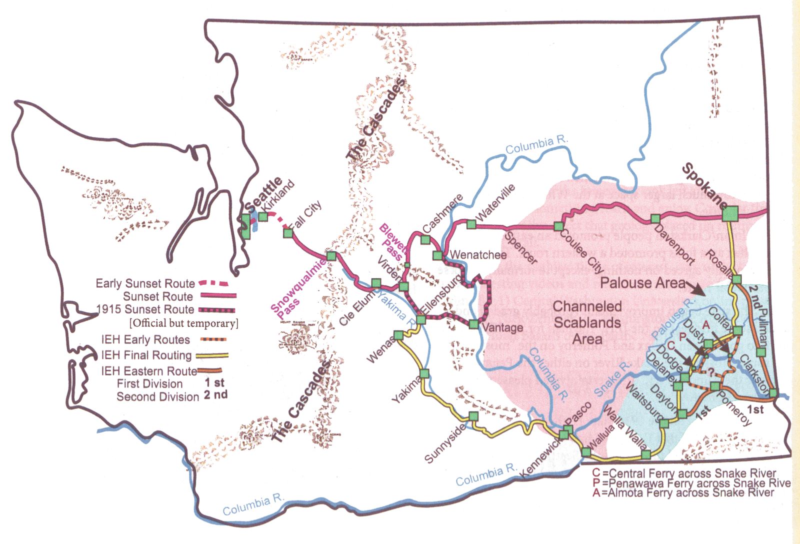

The Sunset Highway was established in 1913 as a primary state highway and on July 1, 1915 the highway was officially completed and dedicated.
The 1915 route originally began at the Pacific Highway in Renton.
The traveler departed Seattle and headed south on the Pacific Highway.
When reaching Tukwila the traveler would have taken Macadam Road east to Renton Junction.
The original bridge crossing at the Green River is almost in the same spot as the new bridge found today on Southcenter Blvd.
The traveler continued eastward to North Bend, over the Snoqualmie Pass, through the towns of Easton, Cle Elum and Ellensburg.
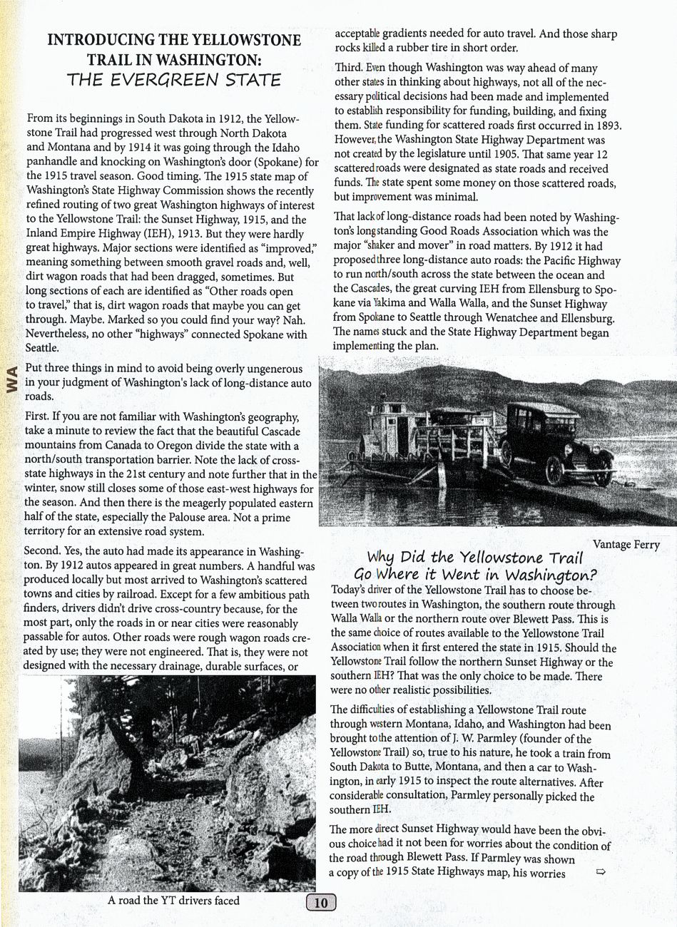
The road then continued east to Vantage where you had to take a ferry across the Columbia River (crossing #1).
From the east side of the river, the road continued north to Quincy and then west to another ferry across the Columbia (crossing #2).
From here the highway meets the Old Colockum Road and follows it north to Wenatchee.
From Wenatchee the traveler crossed the Columbia River for a 3rd time (on a bridge) and continued north to Waterville.
From Waterville, the traveler continued eastward to Spokane.
In 1913 the concrete bridge over Latah Creek was opened for traffic. This new road and bridge bypassed the old wagon road, which gave motorists a better approach to the city.
In 1922 the road was improved and the route was changed.
After reaching Cle Elum from Seattle, the new route continued north over Blewett Pass to Peshastin and then eastward to Wenatchee.
In 1926 the Bothell branch was established and motorists could chose between driving around the north end or the south end of the lake.
The Yellowstone Trail used the Kirkland Ferry to reach Seattle from Fall City.
In the late 1920s, the route of the highway changed again when a new highway was built at Renton. The new road was built over the hill east of Renton where it connected to the Pacific Highway in Seattle.
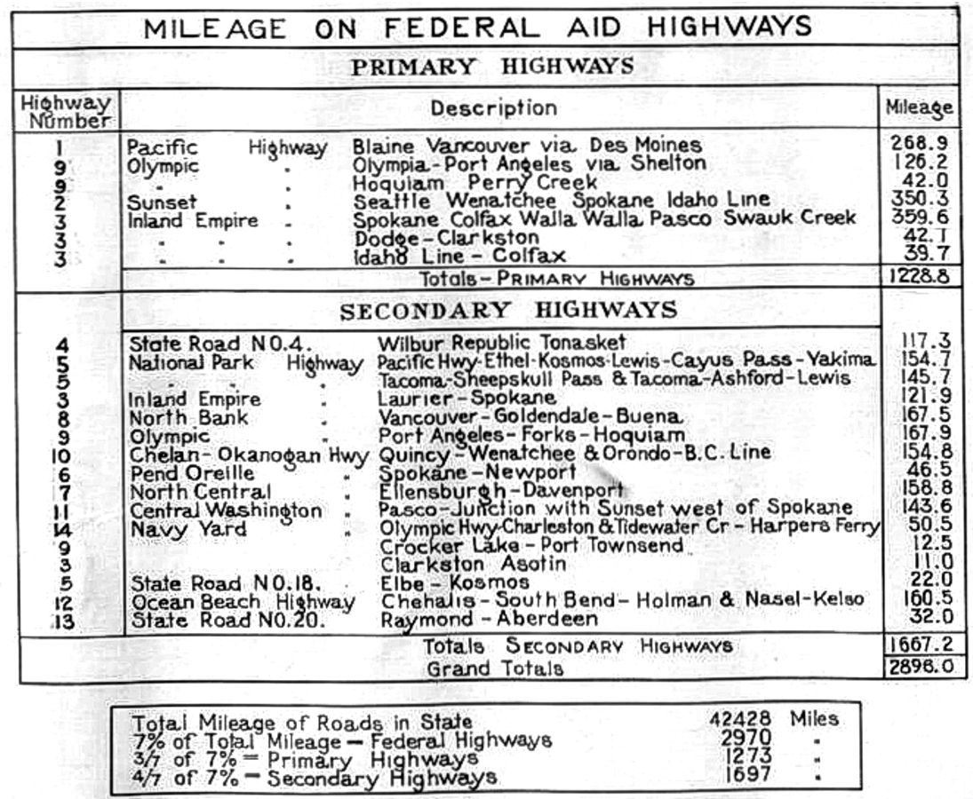
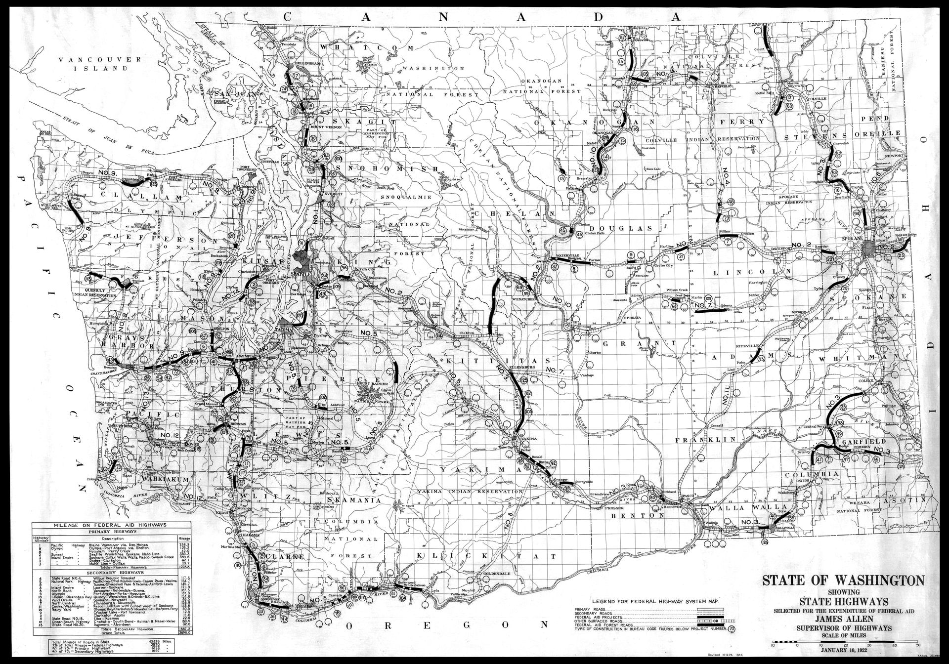
In 1924, the State released a map showing where Federal Aid was used. Refer to Legend in 1924 Map below.
By 1934, the concrete paving had been completed between Seattle and Spokane.
During this time, the highway received official designations as State Road No. 2, Primary State Route No. 2, and U.S. Highway 10.
In 1936 the Echo Lake cut-off was completed, and this new route bypassed Fall City, Snoqualmie and North Bend.
In 1940 the Evergreen Point Floating Bridge was completed and the new 4-lane highway bypassed Renton.
Today most of the old highway is called by different names, but the name “Sunset Highway” has
persisted and is still alive in places between Renton to Spokane.
The words above are from The Historic Sunset Highway website.
Now that you perhaps have a better understanding of the Yellowstone Trail and / or The Sunset Highway, please read the article below by Douglas County Museum Director, Dr. E. F. Cater, which appeared in a recent YTA Newsletter:
Dr. E. F. Cater, Director
Douglas County Historical Museum
124 W. Walnut St, PO Box 63
Waterville, WA 98858
509·745·8435 • dchs@nwi.net • www.douglascountymuseum.com
Underneath that winter-worn, washboard that we call asphalt lays a golden treasure. Except for a lonely sign on the corner of Walnut and US Highway 2 (Central Avenue) few people traveling through Waterville, Washington know they are driving the Yellowstone Trail.
To local folk, it has long been called the Sunset Highway. Except for the thirty curves in Pine Canyon that will confuse your inner compass by taking you east to go west and north to go south, the Sunset Highway will take you straight to a Pacific Ocean sunset. If you take a long day’s drive in the opposite direction you will end up on the north end of Yellowstone National Park in Livingston, Montana.
Underneath personal delight in our dot on the map, we know history almost passed us by without as much as a hello. Pioneer settlers found it nearly impossible to get their wagons here. They finally took an arduous stab at it and arrived in 1882… Almost ten years ahead of the government land agents. When the railroad finally decided to venture here in 1909, they bypassed Waterville because of cost.
Waterville, Washington sits at nearly 3,000 feet on the largest plateau anywhere. Surrounded by rugged basalt cliffs, travel proved difficult. In a time long past, getting things in and out required a tram system down to the Columbia River. A more gutsy person might go after their own stuff by taking a steep and treacherous wagon ride on a narrow and rocky trail using a 6 or 8-horse hitch.
The Yellowstone Trail Highway (YTA) executive committee changed all of that. The original trail through Washington took a 430-mile dip south from Spokane almost to Oregon, then west toward Seattle. The YTA Executive Committee investigated and found that two hundred and fifty-seven miles could be cut off that trip by going through Waterville.
So, way back there on May 14, 1925, the Big Bend Empire Press in Waterville energized the public with the news that the Executive Committee of the YTA investigated the Sunset Highway and decided to make it part of the Yellowstone Trail.
The traffic count on the Yellowstone Trail at Spokane indicated two-thirds of the tourists traveling to and from Yellowstone followed the trail south through Lewiston, Walla-Walla, and Yakima. Changing the route to follow the more direct route on the Sunset Highway represented the most significant advancement in the Yellowstone Trail system.
This change took an entire day of travel out of the trip. Using the average 30 miles-per-hour that a car traveled in 1925, it took 14.5 hours to drive that southward loop. Driving the sunset highway through Waterville to the same point at Cle Elum took 5.8 hours.
At that time, the YTA had the ear of the US Department of Transportation and they used their suasive voice to move the Sunset Highway to the top of the list for paved roads. In part, the YTA organized to enable personal automobile travel and put an end to the muddy roads. And they pressured local, state, and eventually the federal government to build good, long-distance roads.
They developed and published their plan for a transcontinental highway that allowed tourists to travel from the Atlantic to the Pacific Oceans. Maps did not exist, so the YTA wrote guidebooks, and communities along the trail marked the trail with rocks painted yellow. Their influence and drive pressured Yellowstone National Park into opening the park to automobile traffic. Something the National Park administration fiercely resisted.
The marker signs put up by the Yellowstone Trail Association have long since disappeared, but the Yellowstone Trail became the premier tourist route early in the life of automobile travel. In 1925, a person could obtain a 24×36 folded map with booklets and strip maps. Armed with accurate information, people could go see odd and beautiful curiosities everywhere, and along the way Yellowstone National Park.
Cafés shaped like a coffeepot, billboards, and full-service gas stations popped up in towns along the way. Motels (motor hotels) with signs that claimed Duncan-Hines slept here and Betty Crocker ate here joined in the chorus. Then came those must-read Burma Shave slogans, and signs telling you how far it is to Wall Drug. An entire commercial world grew out of the work of the YTA. Sadly, much of this wonderful Automobilia world has returned to the dust of the earth.
In Waterville, five motels and hotels, six restaurants, and five gas stations sprang up to accommodate the traffic that came with the blacktopped Yellowstone Trail. One of the original restaurants and one gas station remains. The gorgeous Waterville hotel now sits empty. Nowadays, faster travel scoots the traffic past all the wonderful things to see in the Big Bend of Washington.
Maybe you will choose to visit Waterville and stop in to see us at the Douglas County Museum. You can cheer our spirit by taking your picture in front of our Yellowstone Trail sign. Then make sure you sign our guest book.
When spring has sprung, I’m finding a big rock to paint yellow!
Reference
Ridge, John W., and Alice A. Ridge. A Good Road from Plymouth Rock to Puget Sound: A Modern Guide to Driving the Historic Yellowstone Trail 1912-1930. Altoona, WI: Yellowstone Trail Publishers, 2021.